From: Ben Discoe [ben@vterrain.org]
Sent: Saturday, March 18, 2006 10:42 PM
To: WTG Committee
Subject: 3/18 Trail Update
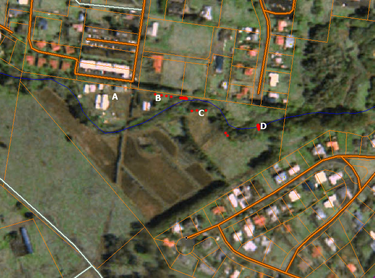
Today (Saturday) i spent several hours on the Ag Land section of the trail. Here is some status on progress. The map image below shows reference points. Areas where i chopped brush are shown in red. I expended energy on advancing both of the most commonly mentioned possibilities:
- Straight along the northern edge, with a bridge at the eastern edge.
- South of the stream.
Today's activity:
- Walked south of the stream into the Ag land, crossed the bridge to explore the School area (A on the map). Rather than being a collection of temporary structures, the school proved to be actually quite solid and impermeable, with grounded chain-link fences and heavy buildings on cement foundations. Putting the trail through the school (as has been mentioned) is clearly a no-go.
- Walked around the Ag Research greenhouse (B on the map) to the northern edge of the parcel. Here is a line of Norfolk trees, with only tall grass, a few large branched, and Wattles (weed trees) interfering with pedestrian access. I chopped some Wattle and proceeded east.
- Encountered a large Christmas Berry tree, which after a large amount of hacking and lopping, revealed itself to be hiding a huge rock outcropping. This pinches the trail between rock and streambed, forcing the trail down badly toward the flood zone. Shortly beyond, it became completely untraversable. The claim that this area has been surveyed and recommended for trail are absurd, as anyone visiting the area can see plainly.
- Retreated back the way i came, and chopped weedy Castors and Wattles along the Ag road (C on the map).
- At the area the Parker School kids previously attempted to cross the stream (D on the map) i used lopper and Cane knife to clear the path down to the streambed, and then with tremendous effort attempted to clear a path up the other side of the stream. This is a 25 foot wall of solid matted cane grass, with live cane holding together the wall of dead cane and river garbage. By the time i had to stop, progress was only partway up the bank.
Some conclusions:
- Putting trail along the northern boundary of the parcel is unworkable, likely requiring such radical steps as changing the path of the stream and demolishing buildings. The parcel contains two effectively impossible "pinch points" on the northern boundary.
- Putting trail along the south side of the stream, from one end of the parcel to the other, is by comparison straightforward and efficient, bordering on obvious.
-Ben