that drawing resulted from the notes gathered on the
080701 trail
walk
Old Schematic
map of the Trail (PDF)
This is a very rough sketch as of the mid 1990s, however, until 2007 it was
the only "official" drawing we had in computer form.
Plan drawings: Bruce did first segment renditions drawings. There
were so many changes since then in regards to easements etc. that Bruce wanted
to wait for the easements to be firm before doing further drawing work.
Things remained like that for many years.
In February 2007, a set of 18 drawings were released (drafted by Bruce)
The rest of the trail drawings that have been produced over the years have
been sketches as the WTG has worked with landowners, mostly drawn by Kaz and
Clem. Kaz and Clem are architects working on paper, so it is a bit difficult
to post their drawings here on the website in electronic form.
Reportedly, drawings exist of the trail easement through all Parker Ranch
lands. Here are three documents from the surveyor, Bob Shirai, showing
some of the Parker easements:
5-A 072606.pdf from the
top of sandalwood, through Parker land to the ag parcel.
7 072606.pdf along the entire
length of sandalwood, hugging the stream.
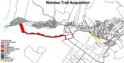
Output from a GIS view, presumably August 2005, showing all
the various easement whose rights need to be acquired for the trail.
It's not known who produced this view, but it's encouraging that
at least somebody is using GIS.
Trail markers
Three drawings of how the trail sign and information stand could be
built: L2.pdfL3.pdfL4.pdf
Surrounding Parcels:
Carter Parking Lot, date
unknown (presumably Summer 2005)
Shows part of a drawing of the expansion of the parking lot which is the focus
of discussion between Carter, WOC, WTG and the NRCS.
Trees on the Trail Edge of Carter
Parking Lot, 2005/9/8
This drawing is the result of informal surveys taken by Avi, Victor and Ben
of the trees still standing. There are 46 labeled trees. Scale is
15 pixels/foot.
Possible Route of Trail along Carter
Parking Lot, 2005/9/12
This is just a tentative sketch, but it was received well at a 2005/9/9 meeting
with representatives or WOC, WTG and Carter. The arborist has not yet
considered this plan, and the final trail design is still a ways away.
Environmental Impact
There was an EA (Draft Environmental Assessment) published October 2002.
Unfortunately, the only copy found so far is a 3MB PDF of a scan of the paper
pages. Where is the original document in electronic form?
Since it was prepared for the County Parks&Rec dept., maybe they have
it.
It is full of very useful information! For example, it is the
only document where the construction increments are described:
PATH (Peoples Advocacy
for Trails Hawai`i) is a Big Island organization promoting
traffic safety education and improving conditions on roadways and trails for
recreation, fitness, and alternative modes of transportation.